
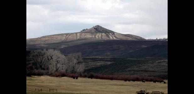
The long road to Signal Peak
Will Shoemaker
Times Editor
Elijah Waters quickly earned a reputation after taking the helm of the Bureau of Land Management’s Gunnison Field Office in 2015. When a proposal for a new project landed on the desks of office staff, Waters was quick to ask, “What does the plan say?”
Specifically, the field office manager’s frequent query was in reference to the area’s Resource Management Plan — a big-picture document that stipulates suitability for certain activities, such as grazing or recreation.
“A plan is essentially a contract for how you manage that land,” Waters explained. “When you start to deviate from that, that’s when you get in trouble.”
That idea has formed the basis for BLM’s proposed action for a new, non-motorized singletrack trail system on a 13,000-acre swath of land in the vicinity of Signal Peak northeast of Gunnison for which comments are now being accepted. Agency leaders point not just to the 1993 Resource Management Plan, which identifies managing lands including Signal Peak for “a diversity of recreation opportunities,” but also subsequent, public-involved planning processes over the last decade in paving the way for the controversial trail system.
At the same time, however, sportsmen and ranchers say they’ve not been sufficiently heard and are mounting a fight against what they view as unbridled recreation development.
A long history
For decades, hikers, runners and mountain bikers have used the singletrack and doubletrack trails in the vicinity of Signal Peak for recreation and training — many of them old wildlife and cattle trails, or rudimentary roads first used for mineral exploration.
When Dave Wiens came to Western State Colorado University as a freshman in 1982, singletrack routes built by former ski coach Ken MacLennan were in place and used frequently by athletes preparing for the national stage.
More than two decades later, Wiens would form the singletrack advocacy group Gunnison Trails, which adheres to a mission of maintaining routes, educating users and pursuing new trail opportunities. The latter of those objectives resulted in the nonprofit in 2006 pitching three separate proposals — Signal Peak, a system northwest of the city and the Gunnison-to-Crested Butte trail — as part of a years-long effort undertaken by the BLM and U.S. Forest Service to manage backcountry travel in the basin.
“Our proposals were very purposeful,” explained Wiens, now a Gunnison Trails board member. “They’re trails adjacent to and accessible from the City of Gunnison.”
Following significant involvement by local elected leaders, other advocacy groups and the public, the end result was the 2010 Gunnison Basin Travel Management Plan. In it, however, only one of Gunnison Trails’ three proposals was given clear go-ahead — Signal Peak, between Gunnison to the west and Cabin Creek to the east.
“While the goal of this system of new non-motorized trails would be to provide trail loops of varied lengths, the exact location of these trails has not been determined,” the document stated.
A way to manage recreation
At the time, Gunnison Sage-grouse remained a major concern, with the bird’s possible federal protection looming on the horizon. As a result, BLM subsequently undertook writing a document called a Candidate Conservation Agreement (CCA), which sought to identify threats and enact protective measures to avoid the need to “list” the bird under the Endangered Species Act.
It singled out recreation among the threats. However, the CCA identified the Signal Peak area and Hartman Rocks as so-called Urban Interface Recreation Areas “that would be managed for recreation use” — the thought being that keeping recreation close to Gunnison would protect outlying populations of the bird from future harm. The CCA received approval from the U.S. Fish and Wildlife Service, which determines whether species warrant federal protection.
While Fish and Wildlife ultimately listed the grouse as “threatened,” as opposed to the more restrictive “endangered” designation, the contents of the CCA were rolled into the a Rangewide Management Plan amendment for the Gunnison Sage-grouse for which BLM accepted public comment from last August until January of this year. The document is currently awaiting final agency approval.
With the Signal Peak concept given a thumbs up in both the travel plan and CCA, BLM recently released the proposed action which identifies 7.8 miles of existing trails and 20 miles of newly constructed non-motorized routes — with a condition of seasonal closures to protect grouse and wintering deer herds.
“There’s no reason to think that wildlife and recreation can’t get along simultaneously if managed well,” said Gunnison Trails Executive Director Tim Kugler. “We can be a model for other places.”
Sportsmen left out?
In 2014, Gunnison Trails received $45,000 through the Colorado State Recreation Trails Grant Program to produce a plan for the Signal Peak trails. BLM partnered in the grant application, and in the ensuing years the trail advocacy group walked routes, surveyed the public and produced a master plan for the area.
As proposed to BLM, the document contained 45 miles of trails, which the agency whittled down to 28 over the last few months.
However, a group of sportsmen called Gunnison Wildlife Association (GWA) — which remained dormant for years after originally forming in the 1990s — was recently resurrected, and its members take issue with a sentence contained in the Signal Peak master plan. It reads: “The BLM also asked Gunnison Trails to confine outreach to Gunnison Trails constituents and not try to engage the broader interested community, including motorized trail users and sportsmen.”
To sportsmen, it’s proof that their concerns have been bypassed. However, BLM recreation planner Jim Lovelace says the agency’s direction was in an attempt to keep other user groups from muddying the task at hand — producing a plan for non-motorized singletrack after the BLM in both the 2010 Travel Management Plan and CCA had deemed it a priority.
“The reason those other entities weren’t contacted was because that wasn’t the user group that would be using that trail system,” he added. “What we’re looking for now are specifics. Are there any issues or concerns that are not addressed through the elements in the proposed action?”
Additionally, Lovelace noted that the trail system is a way of managing recreation long into the future.
“We’re not just managing for this year or this season,” he said. “This is our way of saying that as the needs of recreators dictate, as more people move into the valley, this is a tool we can use.”
Still, the BLM maintains that a final decision has yet to be made. For example, “no action” — meaning trail construction would not be approved — is a possibility.
‘A big deal for wildlife'
GWA has raised numerous additional concerns about the plan — including fears that the BLM doesn’t have the resources to enforce seasonal closures, possible impacts to deer that live in the area year-round and further degradation of the grouse population.
“How do you explain to a community that’s paralyzed by sage grouse listing that it’s OK for bicycles to invade every space?” GWA board member Navid Navidi posed.
There is currently one “active” lek — or area where birds strut during the mating season — within the Signal Peak area, according to Colorado Parks and Wildlife conservation biologist Nathan Seward. To be considered active a lek must exhibit at least two males for two counts in the same year.
The active lek has seen a reduction in males counted in recent years, Seward said. For example, “high-male count” at the lek has steadily declined from 17 in 2009 to three this year.
Two additional leks exist in the area as well — one which has not shown enough birds to be considered active, and another that has been void of birds since counting practices were standardized in 1996. Until this year, that is.
“I was up there this spring and lo and behold, here’s one male right on that ridge strutting,” Seward said.
GWA has collected more than 500 signatures by people opposing the Signal Peak system, and through that process they say they’ve learned the public is largely unaware of the plan. Yet, the group’s opposition also stems from the viewpoint that the Gunnison Valley already offers enough opportunities for trail-based recreation — and that any new routes will only place additional pressure on natural resources.
“We’re not here to say whose fault it is,” said GWA board President Lowell Inman. “We’re just saying, the public needs to know. This is a big deal for the future of wildlife in the basin.”
(Will Shoemaker can be contacted at 970.641.1414 or editor@gunnisontimes.com.)